Streets and Hurricanes
On an earlier post, I alluded to the fact that street names here are another interesting story. The short story is, there are no street signs for the most part. Maps indicate street numbers - we live near 394, for instance - and these numbers can sometimes be found on the streets themselves while driving. But people who live here have no idea where 394 is. Instead it might be described as the first northside road that runs parallel to Skyline (aka 40). Basically, people here seem to make up names based on landmarks and sometimes those names catch on and other people use them too. For other roads though, there are many different names for the same road.
Skyline is the road that runs along the hills from east to west. Skyline and Veterans are the two names that are clear to everyone... I think. Veterans runs along the water right outside my office.
Our landlord calls the little road we live on Tulip Tree Lane. She apparently even placed a street sign out at the entrance to the road. I don't think anyone else calls it this though. Another road near us has a similar hand-painted sign of Lemon Tree Road. I bet you can guess what some of the trees on these roads are. I also know someone who lives on the road near Magens that has the dumpsters. The way the previous tenant gave Dave directions to get here included turning left when a chain link fence is on your left and a stone wall is on your right. It's all about landmarks!
I read somewhere that one of the tourist places has a map with both the street numbers and the street names on it, but we haven't found such a map yet.
In other news.... power went out again twice during the night. Of course, I'm thinking it's not really news. I did find out that when Hurricane Marilyn basically destroyed the island in 1995, parts of the island were without electricity for nearly an entire year. The courthouse restored power in about a month. Most of the island had power in about six months. And this was "only" a category 2 or 3, compared to today's Katrina which is a 5.
For those of you who have no idea where we are and want to know when to worry about us when there is a hurricane, a map of the Caribbean is posted below. My impression is that the major news sources in the states don't seem to voice much concern over the hurricanes until they endanger mainland. So, you can always refer to the map and have some idea of where we are. But, even with the big Katrina storm right now, I think it just gave us a little more rain last week. Other than that we didn't notice it because it was too far away.
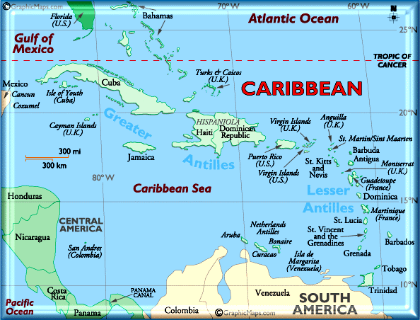
(We're under the two Bs in the big red Caribbean label. The USVI is just west of the British VI.)
Skyline is the road that runs along the hills from east to west. Skyline and Veterans are the two names that are clear to everyone... I think. Veterans runs along the water right outside my office.
Our landlord calls the little road we live on Tulip Tree Lane. She apparently even placed a street sign out at the entrance to the road. I don't think anyone else calls it this though. Another road near us has a similar hand-painted sign of Lemon Tree Road. I bet you can guess what some of the trees on these roads are. I also know someone who lives on the road near Magens that has the dumpsters. The way the previous tenant gave Dave directions to get here included turning left when a chain link fence is on your left and a stone wall is on your right. It's all about landmarks!
I read somewhere that one of the tourist places has a map with both the street numbers and the street names on it, but we haven't found such a map yet.
In other news.... power went out again twice during the night. Of course, I'm thinking it's not really news. I did find out that when Hurricane Marilyn basically destroyed the island in 1995, parts of the island were without electricity for nearly an entire year. The courthouse restored power in about a month. Most of the island had power in about six months. And this was "only" a category 2 or 3, compared to today's Katrina which is a 5.
For those of you who have no idea where we are and want to know when to worry about us when there is a hurricane, a map of the Caribbean is posted below. My impression is that the major news sources in the states don't seem to voice much concern over the hurricanes until they endanger mainland. So, you can always refer to the map and have some idea of where we are. But, even with the big Katrina storm right now, I think it just gave us a little more rain last week. Other than that we didn't notice it because it was too far away.
(We're under the two Bs in the big red Caribbean label. The USVI is just west of the British VI.)
posted by Kendra at 10:08 AM
![]()
![]()

1 Comments:
Found a good map of St Thomas online -
http://www.usvi-on-line.com/st/stmap.shtml
Post a Comment
<< Home